
Map-Library Perry Castaneda
Geography is magical knowledge: linking people, space and perception, it seeks to enlighten the mind of the traveler. As it mixes subjectivities in an aspiration to build objectivity, the geographer is a visitor who refuses to rely on the comfort of ready-made ideas.
Lets have a look at a specific example, by going to a place that has become such a myth that ready-made ideas abound on both the area and the people living there.
A beating heart for the legendary United States of Murica (as they would say with their truculent accent): Texas !
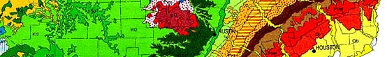
What can we see there? The good city of Austin, of course and the tremendous work of the Perry-Castaneda Map Library in the Austin Branch of the University of Texas.
Austin, thanks to the miracle of geomarketing is now known as the "Live Music Capital of the World. A very surprising city in the US indeed! The high prices of real estate in the Silicon Valley have made Austin a secondary pole of the hi-tech industry. Companies like Dell, Apple, Freescale, IBM, Hewlett-Packard, AMD, Texas Instruments or National Instruments all have their corporate headquarters in the city.
 Austin's ranking as 14th city in the US with a population of 1 716 289 in 2010 is mostly due to this technological enthusiasm.
Admittedly, the creation of the University of Texas in 1883 foreshadowed a bright future... But let's not forget that Janis Joplin herself abandoned her studies to speak to the world! It seems UT has learned a lot from previous mistakes. Nowadays, in the very heart of the numeric anthill, the university is not afraid to reach out to the whole world. Best Public University in Texas, 44th university with over 50 000 students. Of course, UT was destined to be a reference on the Web And enter of course to the Wonderful Wired World!
We wont take a look at any of this revered academys websites. Instead, we will focus on a more interesting one (in our librarians eyes): the Perry Castanedas Map Library.
This website offers a wide collection of royalty free maps, scanned and organised by locations, countries and cities. This is a useful directory to find maps, GIS data or to start a diachronic analysis on a city's evolving urbanisation You can also use this database to understand how maps were drawn through the years! Of course the USA in general and Texas specifically speaking are more represented than any other area. But the whole world is waiting for you there.
Have a glimpse of the Antarctic, or the different ethnolinguistic groups of the Caucasus You can find most anything in the Map Library! On the homepage, go to « Online Maps of Current Interest » to access a collection of maps related to the most important breaking news, such as the situation in Mali, Syria or the price of oil in the US There are many more topics to be found there!
Geography is magical knowledge: linking people, space and perception, it seeks to enlighten the mind of the traveler. As it mixes subjectivities in an aspiration to build objectivity, the geographer is a visitor who refuses to rely on the comfort of ready-made ideas.
Lets have a look at a specific example, by going to a place that has become such a myth that ready-made ideas abound on both the area and the people living there.
A beating heart for the legendary United States of Murica (as they would say with their truculent accent): Texas !
What can we see there? The good city of Austin, of course and the tremendous work of the Perry-Castaneda Map Library in the Austin Branch of the University of Texas.
Austin, thanks to the miracle of geomarketing is now known as the "Live Music Capital of the World. A very surprising city in the US indeed! The high prices of real estate in the Silicon Valley have made Austin a secondary pole of the hi-tech industry. Companies like Dell, Apple, Freescale, IBM, Hewlett-Packard, AMD, Texas Instruments or National Instruments all have their corporate headquarters in the city.
Austin's ranking as 14th city in the US with a population of 1 716 289 in 2010 is mostly due to this technological enthusiasm.Admittedly, the creation of the University of Texas in 1883 foreshadowed a bright future... But let's not forget that Janis Joplin herself abandoned her studies to speak to the world! It seems UT has learned a lot from previous mistakes. Nowadays, in the very heart of the numeric anthill, the university is not afraid to reach out to the whole world. Best Public University in Texas, 44th university with over 50 000 students. Of course, UT was destined to be a reference on the Web And enter of course to the Wonderful Wired World!
We wont take a look at any of this revered academys websites. Instead, we will focus on a more interesting one (in our librarians eyes): the Perry Castanedas Map Library.
This website offers a wide collection of royalty free maps, scanned and organised by locations, countries and cities. This is a useful directory to find maps, GIS data or to start a diachronic analysis on a city's evolving urbanisation You can also use this database to understand how maps were drawn through the years! Of course the USA in general and Texas specifically speaking are more represented than any other area. But the whole world is waiting for you there.
Have a glimpse of the Antarctic, or the different ethnolinguistic groups of the Caucasus You can find most anything in the Map Library! On the homepage, go to « Online Maps of Current Interest » to access a collection of maps related to the most important breaking news, such as the situation in Mali, Syria or the price of oil in the US There are many more topics to be found there!